Tuesday, July 30, 2013

Baby Water Snake

On our evening walk, we found this baby snake hanging out in the shallow water of of the San Gabriel River.  Our best guess at an identification is the Blotched Water Snake based on the information provided by the Austin Reptile Service.  The body was narrower than my pinky and about 1ft long.


Update - 2013.10.11 - This evening we found another snake with very different patterns.  Surprise to come up with the same identification but for an older snake. Since the two were found within 50 feet of each other, it might even be the same snake!


Sunday, July 21, 2013

Goose Island Camping

This past week, we took a summer camping vacation to the Texas gulf coast. Surprisingly, this was our first trip to the coast, at least for vacation purposes. In the past, we had not been sure that we could bring our dogs anywhere but it dawned on us that the state parks would accommodate them. This was to be a kayaking trip with some bird watching. Even though this is not the best season for birding, we figured it would be a good practice trip, especially to see how the dog did.

Goose Island State Park- We made home base atGoose Island State Park, north of Rockport. The park has two sections, one part on shore in a wooded area and one part out on shores of the island itself. We chose the wooded area since it offered more privacy. We were pleasantly surprised that the mosquito population was less of an issue than we had expected, though DEET was still a requirement. The shore sites were exposed to the strong evening wind blowing the first half of the week. The park is clearly a haven for fishermen. Those camped on the shore sites were able to cast their lines from just outside their campers!

Based on our reading, we were anticipating WiFi access, though weak, at the park. This was the purpose of last week's long range WiFi antenna project. Unfortunately, what we did not realize was that only the shore section of the park had any coverage at all. My antenna was not capable of pulling in a signal over a mile away. Danielle, who still had to access work, drove several nights to the other end of the park for an hour of on-line computer time.

A fishing boat launch is located on the short causeway out to the island. There, I stopped and watched a flock of Brown Pelicans and Laughing Gulls scavenging for tidbits around the fish-cleaning table.


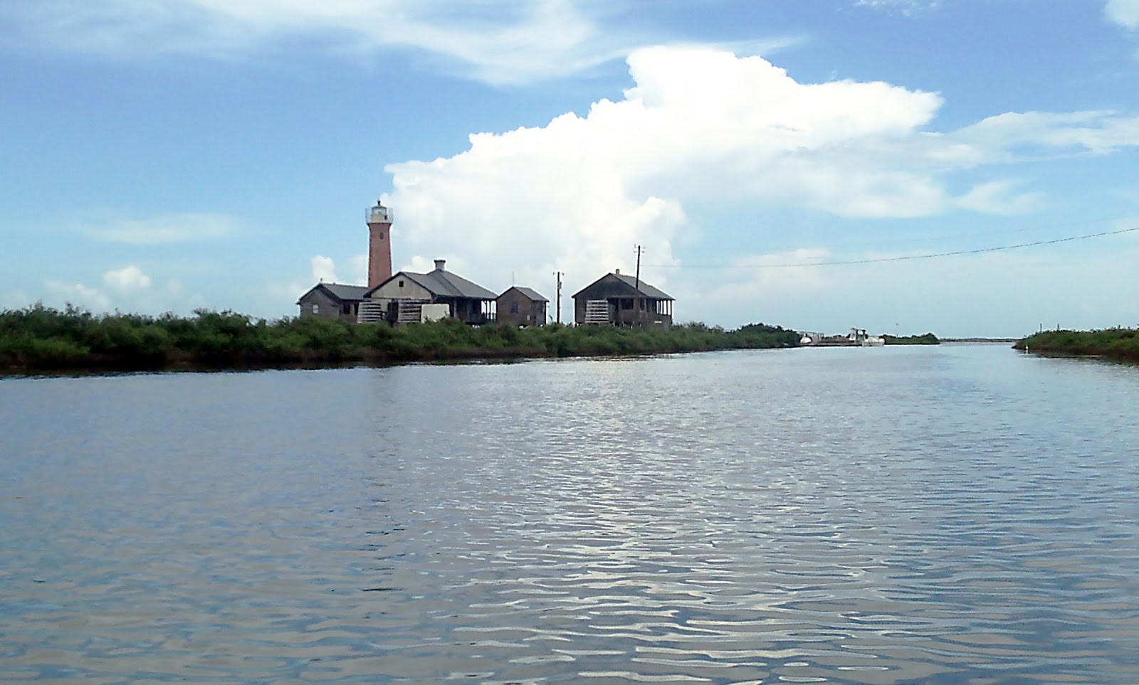
Lighthouse Lakes - On the north side of the causeway between Aransas Pass and Port Aransas is a shallow marshy area dotted with mangrove bushes. This area is called Lighthouse Lakes for the old lighthouse which still stands. This area has several marked paddling trails and is popular with both fishermen and nature-watchers such as ourselves.

This was to be our main kayaking destination for the week and was about a 25 minutes drive from the camp. Mustang Island State Park is slightly closer but requires passage on the ferry. We launched from the city park along the causeway and were able to back the truck right up to the water.


Separating the paddling area from the launch point is a wide navigation sea channel with various boats from fishing trawlers such as the one below to small fast boats. These have right of way so kayakers have to time their crossing appropriately.


In the back well of our Wilderness Systems Commander 140 boats, I built a carpeted platform for Vali to stand or sit in. These boats are stable enough to pull him back in the boat out of the water. Unfortunately, this was a common occurrence. As a water-crazed Labrador, sitting still in the boat was a real struggle for him. He clearly thought the purpose of the trip was to throw bumpers (retrieving toy) into the water for him. We are going to need to do a lot more obedience training under the distraction of nearby water.

Here we are shoving off from the launch point ...


... and preparing to cross the channel behind us.


At one point, I attached a bumper to the back of the boat to keep Vali from whining continuously. You can see what I mean in the picture below. I was surprised by the gusto with which he attempted to pull the bumper. At one point, he actually backed his hind legs up onto Danielle's back while tugging. He then fell in and, still holding the bumper, came up on the back side of the boat and started pulling the boat back up the lake. I wish I had taken a movie but I was laughing too hard to breath.


Most of our paddling was in very shallow water, rarely more than 2' deep and often only 6" deep. The floor of the lakes is very squishy and smelly mix of silt and decaying vegetation, like a really badly maintained aquarium. Much of it covered in grasses that shelter fish. We saw many Mullets breaching out of the water across the lakes. Here is a shot of my boat skimming over the grasses.


Less friendly were these things which I gather are oyster beds. Sometimes found in isolated clumps on the muddy bottom, sometimes forming shallow islands. They are razor sharp as we found out when we ran aground in a patch of them. Vali jumped out on to them and sliced several paws badly on Monday, our first day out. I sliced a finger flailing in the mud to push the boat out. That pretty much ended the first day's paddling activity.


After a change of pace on Mustang Island the next two days, we came back to Lighthouse Lakes on Thursday and Friday to better weather. I traced our paths with the GPS each day. The blue trace below shows the 5.5 mile look to the lighthouse situated right on the channel and back again. The yellow and orange traces (we got separated) are from our Friday attempt to reach Quarantine Shores which we aborted early because the wind came up again and we expected a rough slog back to the launch. This was a 7.0 mile loop.


The lighthouse was a very picturesque destination. Though not an active lighthouse, there is still a care-keeper in residence and there is no trespassing on the property. Actually, the lack of any "shore" within the lakes region made dealing with Vali more difficult as there was no place to get out and play for a bit.


Mustang Island - On Tuesday, we decided to check out the paddling on the bay side of Mustang Island. We drove there via Corpus Christi which made for a longer, 1 hour drive. We put in at "Wilson's Cut" a few miles north of the state park. I was glad I had entered the way-points in the GPS because there is no signage. A short dirt track leads from the main road to the launch point at the head of the cut. We saw one other kayaking group but mostly outboard motor boats using this as an access point to the bay.

Here, Danielle is taking the edge off of Vali with ten minutes of bumper throwing before we launched.


The wind was brutal that day, blowing straight down the cut from the seaward side of the island. We only did a mile before packing it in. The last stretch back to the launch along the cut was very strenuous; amazing what a "sail" your body makes in the wind.


Tuesday night saw very heavy rain fall which continued on and off all day on Wednesday. We decided to leave the boats at camp and take a driving tour back to Mustang Island. I snapped a screenshot of the weather radar on my iPhone showing the rain clouds funneling up through our area.


This time, rather than taking the long way down and around Corpus Christi Bay, we took the ferry to Port Aransas. I think this is the first time I have been on a car ferry.


In Port Aransas we stopped for lunch and one of the little eateries called Miss K's. The proprietors were very friendly to Vali and we didn't have to leave him in the car. I don't think they would have been as impressed if they could see him on the kayak.


After lunch, we stopped at Mustang Island State Park to see the coast proper. After wading out to the the beach through a parking lot and picnic area flooded with cold rain water, I was amazed how warm the seawater felt. This trip was Vali's first exposure to salt water and he was continually frustrated at not being able to drink out of his own bathing water. The small waves, however, did not phase him a bit ... any place is a good place to fetch bumpers. We did not venture out into any real surf or depth.


Here again at the jetties at "Fish Pass," we let him off leash for another round of fetch-in-the-surf as the storm clouds remained at bay for a while. This spot looks like it was once a channel cut back into Corpus Christi Bay but is now dried up.


The pink granite blocks were fun to wander over and not too slippery. I found a number of roach-sized crustaceans scurrying over them. In one of the tide-pools between the rocks, I found a school of small striped fish washing back and forth as the water surged in and out. They were only a couple of centimeters long.


I at first thought that they were Sergeant Majors until I remembered I was not in Hawaii. After some web searching back at home, my best guess is that they are Sheepshead fry or perhaps Black Drum.


Aransas National Wildlife Refuge - After breaking camp at the end of the week, we stopped at the Aransas National Wildlife Refuge, north of Rockport. This is another likely spot to come back in the winter to do bird watching as Whooping Cranes winter in the area. At noon, in the middle of July, however there were not too many birds around. Even the resident alligator was not to be seen. The mosquitoes, on the other hand, abounded in the wooded areas. This was what we had been afraid of at Goose Island.

We took a quick walk out to the boardwalk on "Big Tree Trail" to look out over the marsh into San Antonio Bay. We saw a few herons and egrets including this juvenile Tricolored Herontaking off and flying out over the water.


While we were watching, a pair of raccoons ambled in under the boardwalk poking around in the mud. I have never seen a raccoon with such light, reddish colored fur. This one stopped when it saw us, turned around, and ambled away.


Over the course of the week we saw many species of birds including some we had not seen before. We were fairly confident in our identification of the following:
  • Northern Cardinal - Ever present in the trees around the campsite. We are well acquainted with their song from home.
  • Laughing Gull - Numerous scavenging around the fishing boat launch points
  • Brown Pelican - Roosting on piers in the bay and scavenging for fish trimmings along with the gulls.
  • Black-Bellied Plover - Poking around in the mud and seaweed along the shoreline at Mustang Island, only saw one.
  • Ruddy Turnstone - Saw several of these on Mustang Island.
  • Roseate Spoonbill - Feeding in the mud and grasses at low tide at Lighthouse Lakes, saw two.
  • White Ibis - On land on islands in Lighthouse Lakes, and one flying at Mustang Island.
  • Forster's Tern or Royal Tern - Small group diving for fish near jetty at Mustang Island SP
  • Neotropic Cormorant - Perching on duck blinds and flying low over the water at Lighthouse Lakes.
  • Great Egret - Perched in the mangroves and fishing at low tide at Lighthouse Lakes and Aransas NWR.
  • Reddish Egret or Little Blue Heron - Perched on a duck blind with Cormorants at Lighthouse Lakes.
  • Great Blue Heron - Fishing at water's edge at Lighthouse Lakes and Aransas NWR. Quite a few of these.
  • Green Heron - Saw one in mangrove at Lighthouse Lakes.
  • Tricolored Heron - Several juveniles at Lighthouse Lakes and Aransas NWR.
  • Red-winged Blackbird - Both saw and heard a number of these on the mangrove bushes at Lighthouse Lakes.
In addition, we saw a number of other shore birds that we were not sure of the identification. I expect a winter trip will yield more birds.

Wednesday, July 10, 2013

Long Range WiFi on Trailer

Danielle and I have camped in a number of locations claiming to have WiFi, only to find that it impossible to connect from our camp-site due to the distance from the access point.  We have used a Verizon MiFi device in the past but we don't always have 3G data access either.  To fix the WiFi range problem, I set up a long-range wireless connection for the trailer.

In addition to better connection strength, one of my other requirements was to create a protected, local wireless network around the trailer in order to connect my astro-photography gear and the remote monitoring computer I use in the trailer.  The wireless router I used for this purpose in the past has since died so I needed to start from scratch.

I got some good starter information on putting together a system from an article by Dick Eastman. My system consists of several parts:
  • Antenna mast and cablingPortable aluminum mast from Buddipole. For the mast, I decided to use a Buddipole that I had in my ham radio gear.  It is a lightweight, aluminum, 6-section telescoping mast with the largest section 32" long and 1-1/4" diameter.  The currently available model at Buddipole collapses smaller but should work equally well.  A more inexpensive option is a telescoping painter's pole from the hardware store.
  • Outdoor antenna and wireless client deviceWLAN-LCCPE28 from L-com. The first electronic component is a single box that contains both an 8dBi antenna and a wireless network device and which mounts on the antenna mast.  It has a single wired port and is powered over the Ethernet cable by a supplied PoE box. This sort of device is typically used as consumer premise equipment (CPE) either to provide a connection to a wireless internet service provider (WISP) or to create an outdoor wireless network.  There are various vendors and models that appear to have similar functionality.  This model was inexpensive and in-stock.
  • Wireless router in the trailerTEW-731BR wireless router from TrendNet. The second electronic device is a wireless router needed to create the local wireless network for my various devices. The wireless capability of the L-com device is used only to connect to the campground network.  It does not simultaneously create such a second network.  That is, it operates either as a wireless client or a wireless access point. This is good; a wireless repeater is not the best option for this application. The router I chose to do that was an inexpensive 300Mbps model with all of the standard features.
  • Client Devices - Several laptops and iOS devices.

Hardware Installation -  The smallest section of the mast, at 3/4",  is too narrow to secure the L-com. However, the end has a 1/2" MIP threads. I purchased a couple of 1-1/2" PVC plumbing fixtures including a bushing down to 1/2" threads.  These screw in securely to the mast end.  The two PVC pieces then come apart for easy removal and storage of the L-com.


I clamped the base of the mast to the spare tire mounting post with some 4" hose clamps. When fully extended, the mast reaches about 7' above the roof line.  At that height, I will probably need to run some guy-ropes as there is flex in the mast but when only a few feet above the roof-line, it is pretty stiff.


Inside the trailer, the wireless router and the PoE box fit easily in the electronics niche above the dining table where there is a convenient AC outlet.


I plan on installing a waterproof RJ-45 outlet jack on the exterior of the trailer and routing the internal Ethernet out of sight.  I will update the post when that is completed. For now, I am routing the cable in through the window in the top rear bunk.


Configure Outdoor CPE AP Client - I followed the included instructions to make an initial, wired connection on the default address, 192.168.1.1. I then reconfigured the device per the screenshots below.

This screen configures the basic settings of the device.  The Device Name is basically the host name on the network. The name I chose, muddypaws-cpe, reminds me that this is the CPE device. Since we own Labrador retrievers, it is easy to guess how we arrived at that name!

The Network Mode is should be set to Router. The alternative, bridge mode, is not appropriate for this application. In router mode, a separate subnet is created though only the wireless router will be connected to it.  This approach allows for a well-defined IP address to access these configuration webpages again regardless of the IP issued to the device by the campground servers.


This page is a bit more involved and is were I configured the network settings.  The WAN Access Type specifies how the device will acquire an IP address from the campground.  Most public hotspots use dynamic IPs, so I set this to DHCP Client.  The host name was automatically filled in from the previous screen.

Having set up the device as a router, I needed to define the parameters of the LAN subnet.  The IP Address is the address of the device on the LAN subnet. The value 192.168.131.254, in combination with the Subnet Mask value of 255.255.255.0, defines the allowable IP address on this subnet. This is also the default gateway for other devices on the LAN. I retained the default non-routable address space of 192.168.x.x but changed to the 192.168.131.x subnet to fit in with my other networks.  I use 254 as the default gateway address on all of my networks.

The remainder of the settings define how this device will issue IP addresses to its LAN clients.  I enabled DHCP on the LAN to simplify direct connection of a laptop for troubleshooting.


On this screen, I configure how the device will interact with the wireless network.  The Wireless Mode must be set to Wireless Client. The terminology varies across vendors; sometimes this is called AP Client. This setting means that someone else has created the hotspot and this device is connecting to it.  If the campground were using the same device, they would set their mode to Access Point.

In client mode, the SSID is the network name of the campground.  In the screenshot, I was testing against my home network called plumerpack.  I did not enter this identifier directly. Rather, I pressed Site Survey to display available networks and, when I selected one, the SSID was filled in.


On some devices, selection of a network from the site survey will automatically bring up another screen to enter the security settings.  On the L-com device, this information is entered manually as a "profile".  On this screen, I created a profile with an SSID matching that returned from the site survey.  I then entered the necessary security settings for my home network.

The site survey and profile definition will need to be redone at each campground.

The two most important configuration settings for the device were:
  • It needed to be configured as a wireless client.  
  • It needed to be configured in router mode.  
Once all of these configuration changes are made I rebooted the device and tested access to the internet through my home network.

In order to re-access the configuration webpages for the L-com, I can simply browse to http://192.168.131.254 or http://muddypaws-cpe from a computer connected either directly to the LAN Ethernet port of the L-com or to the LAN of the wireless router that is described in the next section.


Configure Wireless Router - The WAN port of this router is connected to the LAN port of the L-com on subnet 192.168.131.x.  In turn, all of the computer devices connect to the LAN network of the router on the separate subnet 192.168.130.x.

Configuration is much like any other home router installation.

In this first screen, I configured the LAN settings for the router.  The Host Name of muddypaws-rtr, is distinct from that of the L-com and reminds me that this is the router.

The IP Address of 192.168.130.254 and Subnet Mask of 255.255.255.0 follow my naming convention but define the distinct "130" subnet.

On this LAN, it is important to enable and configure the DHCP Server as this is were all of the computers and devices will connect.  As on my other networks, I reserve the nodes 100-200 for DHCP clients.

I used this screen to define how the router will connect to the L-com.  For the Connection Type, I used the setting DHCP Client or Fixed IP and then for WAN IP, I chose Obtain IP Automatically to get an IP address dynamically from the L-com's DHCP Server. I could also have specified any static IP address in the "130" subnet and set the default gateway to 192.168.131.254 but I was not sure what to choose for DNS servers and maintain for portability.

On this screen, I configured the security settings for the wireless network on the LAN that the computers and iOS devices will connect to.  This is not intended to be an open network. I have used WPA-PSK TKIP successfully with all of my devices on the home network so I stuck with those settings.

Finally, on this screen I configured the settings for the wireless radio on the router.  The SSID value of muddypaws is the network name for my trailer network.

The rest of the settings depend on the type of devices which need to be connected to the network.  In this case, I chose a mixed mode b/g and n.
With this second set of configurations completed, I rebooted both devices.

In order to re-access the configuration webpages of the router at any time, I can simply browse to http://192.168.130.254 or http://muddypaws-rtr from a computer connected to the LAN of the wireless router.


Configure Client Devices - As with the home network, all of our devices work with dynamic IP addresses.  On the Windows computers, the TCP/IP properties are configured as in the following screen. The security credentials are prompted for when I make the wireless connection and then cached in a profile. The iPhones and iPads have corresponding configuration.


Saturday, July 6, 2013

Milky Way Around Albireo

Milky Way and Summer Triangle - Canyon of Eagles, July 2013
Canon 60Da, 6 frames at 600sec, f/6.3, ISO-800 Canon EFS 18-55mm IS @ 18mm
Last night, we did some imaging at the Eagle Eye Observatory near Lake Buchanan. Clear skies were predicted but, instead, we dodged clouds all evening. I had planned to image the region around Antares but the southern sky never stayed clear long enough.  Instead, I ended up imaging the milky way centered centered on the well-known double star Albireo (not resolvable in this image).

I mounted the camera on a auto-guided Losmandy GM-8 equatorial mount.  I used  Astro Photography Tool to focus the lens and capture the images and used PHD Guiding to control the mount.

Hover over the image to zoom in on details. You can see the constellation Cygnus in the upper left with the reddish spot of the North American Nebula and the bright star Deneb. Lyra is to the upper right with the brightest star Vega. The constellation Aquila is at the center bottom with the the bright star Altair.  These three stars form the "summer triangle." A bit below the center left is the small diamond-shaped constellation of Delphinus. Finally, if you look closely a bit below of center, you can find the small pattern of stars called the "coat hanger," though it is upside down in this image. This is one of my favorite of these "asterisms."


Single frame at 600sec, f/6.3, ISO-800
With evening temperatures in the 80's, camera noise was heavy. For comparison purposes, this second image shows a single frame prior to stacking and post-processing.  I can hardly make out any detail. Strong color noise is evident in the image as well as in the processed image but it is amazing what a stack of only 6 frames and a bit of post-processing can do to the image quality!

In retrospect, I forgot to turn on position-dithering in the guiding software which would have improved the smoothing out of systematic thermal noise.  Also, I was only able to get 2 dark frames.

I compensated for the strong color noise by selecting everything but the stars and applying a heavy Gaussian blur in the "a" and "b" channels in LAB mode.  I chose a blur radius sufficiently large to blend the color noise without bleed too much of the milky way colors.  Omitting the stars is critical, otherwise they loose color altogether.  I then pushed the overall saturation on back ground and stars.  I also applied and initial correction to the sky gradient with GradientXterminator.

Aspect Ratio Issue in Deep Sky Stacker

I have been trying to use Deep Sky Stacker with my new Canon 60Da and found a problem with the the saved images.  Frustrating because this is, otherwise, such a convenient program. 

Whereas the preview image in the main application window displays correctly, the image saved on disk after stacking is not. Specifically, the image has been scrunched into the first 75% of the width of the frame.  Interestingly, the resulting image area is square.  It looks like the software is using the pixel height value somewhere it should be using the pixel width value.

The resulting image is unusable.  However, by re-saving the image manually from the main window, the result appears correctly proportioned, though scaled in intensity differently.


Update - members of the DSS group on Yahoo have indicated that this is a problem with Windows previewer not handling 32bit TIF images correctly.   I recalled having this problem as well in Photoshop CS4, but upgraded Photoshop CS6 displays correctly.   The resaved images would have been 16bit TIF.